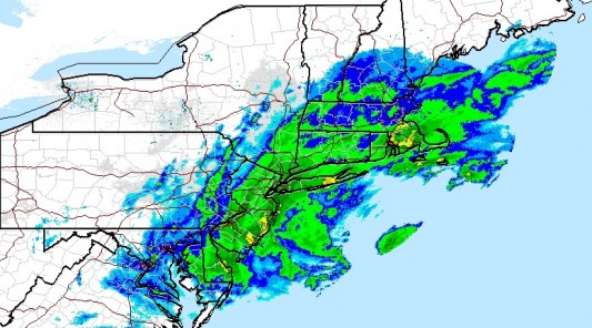
Per the National Weather Service: A low pressure system off the Mid-Atlantic coast will continue to strengthen as it moves north on Wednesday, bringing rain, snow, and/or a mixture of precipitation to areas across the northern Mid-Atlantic and Northeast, as well as wind gusts as high as 60 mph along the coast.
Snowfall across interior sections of New England could approach 6-12 inches. Coastal flooding is also possible. Read More »
Current Watches, Warnings and Advisories for Morris County, New Jersey
Issued by the National Weather Service [RSS] [RSSImport display=”5″ feedurl=”http://alerts.weather.gov/cap/wwaatmget.php?x=NJC027&y=0″ after_desc=”Read More »“]
Real-Time Storm Map
Emergency Shelter
Beginning at 1:00 pm on Tuesday, October 30th, the Borough has opened its shelter at the Sisters of Christian Charity on Hilltop Road. Please use extreme caution while traveling to the shelter; debris and downed poles and wires may be hazardous.
Additional shelter, warming and charging station information can be found here.
Road Closures
- Via Morris County OEM: morrisroads.blogspot.com
- For New Jersey statewide closures visit 511nj.org
Social Media
Social Media is an excellent way to get and pass-on information during an emergency as telephone lines may become congested or not functioning during a storm. It is also a great source of information for emergency information from agencies in the area.
- Mendham Fire Department: Twitter
- Mendham Fire Department: Facebook
- NJ Office of Emergency Management: Website
- NJ Office of Emergency Management: Twitter
- NJ Office of Emergency Management: Facebook
- Morris County Office of Emergency Management: Website
- Morris County Office of Emergency Management: Twitter
- JCP&L: Report a Power Outage
Other
- Morris County Declares a State of Emergency [link]
- Briefings from Governor Christie: watch at livestream.com

